Monticello Rotary Raffle Adventure

Tom Harmon guiding Paddle on WacissaMy friend Tom Harmon invited me to be his guest at a Rotary meeting. Well–knowing the food would be prepared by Mary Frances Dawdry, I said yes immediately because EVERYTHING she prepares is delicious. Besides that, the company at a Rotary meeting is always excellent and they invariably offer interesting speakers.

Another tradition at the Monticello Rotary meetings is a drawing. As their guest, I was asked to draw out a number. I scrambled the tickets around a little and grabbed one.  I didn’t have on my glasses (vanity) so I asked Tom to read out the numbers. He did and then checked my ticket for me and the numbers matched!

I won the prize! It was a canoe trip with Tom and Jeff Wilcox from the headwaters of the Wacissa to Goose Pasture.

The Wacissa is full of birds

This beautiful trip filled in a section of the Jefferson County Rivers I had never seen. I enjoyed the paddle to Blue Spring several times. Ed Green took me through the Slave Canal connecting to the Aucilla. David Ward treated me to a paddle on the north end of the Aucilla when it was in flood, entering at Snead’s Smokehouse landing.

With a larger group, David paddled so I could photograph a segment of the Aucilla from Lamont south to the site of a lost town called Cash Money. Back in 2010, Charlie Ward and Jack Carswell gave me a wonderful photographic tour of the lower Aucilla, Apalachee Bay and the Pinhook, entering the River at Mandalay in Taylor County. Someday I hope to photograph the section of the Aucilla referred to as the “Races.”

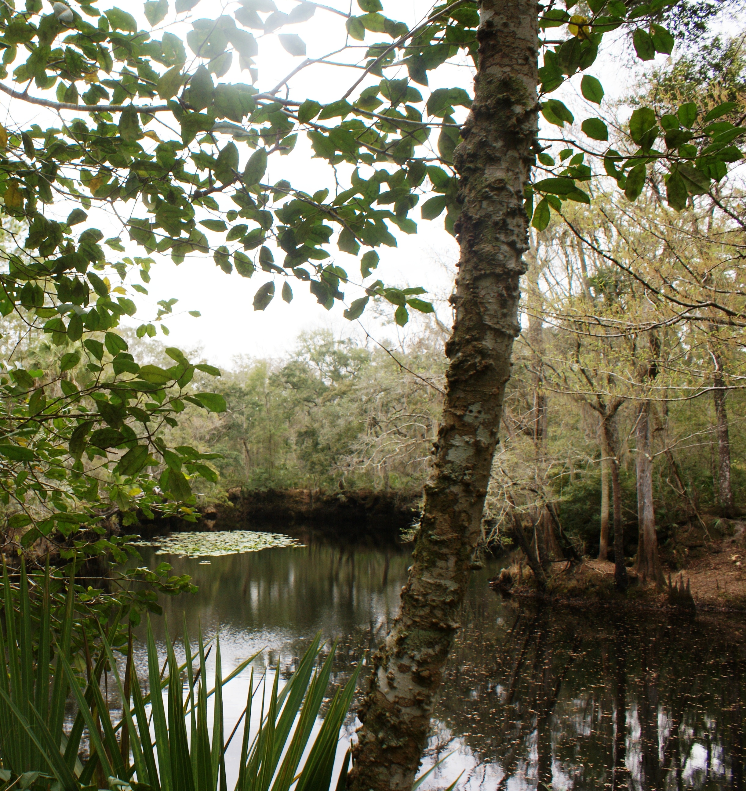
Another time I hiked the underground part of the Aucilla called the Aucilla Sinks. What are called “Sinks” are small and large windows into the underground river forming beautiful small ponds and lakes.  I look forward to seeing the “Races” and completing my photographic tour of the rivers.

Finding our way through the braided channels

Jefferson County Florida Slave Canal

My friend Ed Green took me through wilderness of the famous Jefferson County Slave Canal in a small boat. I wanted to take pictures, and he knew I was worried about my camera and believed the boat would provide more stability for me than a canoe.

The canal was beautiful, breathtaking at times, but believe me, it was a kayaking or canoe trip, not a boat trip. Although Ed’s boat was small and light, it was too much for the obstacles encountered along the trail.

Slave Canal dug by slaves in 1850s to connect the Wacissa and Aucilla Rivers

Slave Canal dug by slaves in 1850s to connect the Wacissa and Aucilla Rivers

We slid under fallen trees, pushed over big sunken logs and made portages. Someone had done some cutting of fallen trees to open the trail, but they were obviously providing for a small canoe or Kayak not even a boat as small as ours.  I’d go back any time, but I would have to go in a kayak or a small canoe. I’ll just buy a waterproof camera so I don’t have to worry about it.

We put the boat in at Goose Pasture. The sky was brilliant blue and the clouds were mysterious snow white shapes. We had to push through heavy grass just under the surface of the water as we moved the boat along the Wacissa toward the turn to the canal. There are signs where the trail branches off, but you have to watch carefully, it would be easy to lose your way. I was thankful to be with someone who knew the turns.

Wacissa River at Goosepasture

Wacissa River at Goose Pasture


I started taking pictures immediately. Shots from the shore alone were worth visiting Goose Pasture landing. As we drifted along the river every scene we passed seemed to be waiting to be photographed. Thank goodness for a digital camera. I would have been sick under the constraints of film.

As we entered the actual Slave Canal Ed pointed out areas of Indian mounds explaining that in this area many of the mounds are very ancient, some even Paleolithic. It was very quiet. We began to see water birds and an occasional gator. There were two or three places where it would have been easy to take a wrong turn, but we managed to stay on the trail.

Great piles of stones, many probably two feet square line one part of the canal. These were piled along the waterway by the hands of men working in this humid, jungle-like environment in the 1850s. It is an impressive sight, worth making the trip through the canal.

We came to the Aucilla along a stretch of water bordered by banks of wildflowers then the cabins and houses of Nutall Rise came into view and we were out of the wilderness.


Jefferson County, Heart of the Red Hills of Florida

Water bird flying up as we passed the Cypress stand.

Water bird flying up as we pass


Jefferson is the only county in the state that reaches from Georgia to the Gulf of Mexico. We are Florida’s keystone. We are separated from Madison and Taylor Counties on the east by the Aucilla River – as beautiful and varied a stream any kayaker or canoeist could find.

The river wanders from cypress forests in the north through miles of live oaks and brush to a tropical paradise in Apalachee Bay. This mysterious stream slips underground for several miles near Goose Pasture to reach the surface in tiny ponds and lakes through openings in the Karst to create Aucilla Sinks.


On the west Jefferson County’s red hills and flatwoods border Leon County. Along Route 90 west, the Old Spanish Trail, you see miles of crepe myrtle’s offering an unmatchable show when they blossom during June and July.

Cold and clear, the Wacissa is spring fed

Cold and clear, the Wacissa is spring fed


A paradise for the hunter, fisherman or photographer, lower Jefferson County boasts the clear cold, spring-fed Wacissa River. Full of birds and wildlife, this pristine river includes magnificent Blue Spring and a canal dug by slaves in the 1850s.  Down in the flatwoods is the wild, hidden Pinhook River. You’ll need a guide to find it.

Before and during the Civil War there was a Salt Works along this river bank

Before and during the Civil War there was a Salt Works along this river bank

AUCILLA SINKS TRAIL

The Aucilla Sinks Trail is part of the Florida Trail – accessible from Monticello, Florida via Route 19 south and Route 27 to Lamont, Florida in Jefferson County

The Aucilla River emerges from swamps a few miles below Thomasville, Georgia and flows southwestwardly, passing over the Aucilla Rapids (referred to as “races” by locals) and then disappears underground a half mile north of Goose Pasture Road. This underground portion of the river is known as the Aucilla Sinks Trail and designated by USA Today as one of the ten best hiking trails in the United States.

These "sinks" are small ponds and lakes formed by windows in the limestone where you can see the underground river.

These “sinks” are small ponds and lakes formed by windows in the limestone where you can see the underground river.

Windows in the limestone to see the underground river

Windows in the limestone to see the underground river

For approximately eight miles the river appears and disappears in a series of small ponds or lakes called “rises” or “sinks.” The river continues this pattern until the great rise at Nutall 0.5 miles north of the US 98 bridge. The Aucilla is joined by the Wacissa near Nutall Rise and flows well straight south, around Ward Island and out into Apalachee Bay and the Gulf.

On Goose Pasture Rd., look for the Florida Trail kiosk on the south side of the road, just before the cattle grate; the Aucilla Sinks Trail follows along that portion of the river that rises through limestone windows and enters the woods to the south, just west of the kiosk.  There are many sinks to follow along this trail. The trail along the River portion enters the woods on the north side of the road, a bit further west of the kiosk; the “races” are about 4 miles north of this kiosk, along the River trail.

Monticello–Seat of Jefferson County Florida

Monticello: Seat of Jefferson County Florida

By Anne Haw Holt

Beginning around 1819 as an Indian Trading Post called Robison’s Corners, Monticello and Jefferson County were officially established in 1827, eighteen years before Florida became a state. The town and the surrounding county were settled by families from Maryland, Virginia, the Carolinas and Georgia. Prince Murat, Napoleon’s nephew was one of our early settlers. James Gadsden, Richard Call and others became Florida leaders. Many of those early families’ descendants still live here.

Filled with beautiful, well-kept antebellum and Victorian homes, Monticello boasts several exceptionally handsome public buildings as well as three structures designed by Atlanta Architect Joseph Neel Reid. Monticello’s quiet streets are beautifully shaded by pecan and magnolia trees and great live oaks hung with Spanish moss. Yards are green and filled with azaleas, magnificent heirloom camellias and other flowering shrubs.

Jefferson County Courthouse, Florida

Jefferson County Courthouse, Florida

Located in north-central Jefferson County at the intersection of the Georgia-Florida Parkway (Rt. 19) and the Old Spanish Trail (Rt. 90) Monticello is conveniently located a short twenty-five minutes east of Tallahassee, Florida’s capital and twenty-two miles south of Thomasville, Georgia. Known as Florida’s “Keystone County” Jefferson is the only Florida county that reaches from the Georgia line south to the Gulf of Mexico.

The beautiful, rolling land around Monticello is green with farms, great hunting plantations and protected conservation land, bordered by the strange, ancient, occasionally disappearing Aucilla River on the east and drained in the south by the brilliant, spring-fed Wacissa River. A good part of the magnificent St. Marks Wildlife Refuge at Newport, Florida (on Route 98) lies in Jefferson County.

SONY DSC

Canoeing the Aucilla with friends

Paddling the Wacissa

Paddling the Wacissa

Paddling the Wacissa

The Wacissa River in Jefferson County Florida is fed by freshwater springs, forming a pristine playground for people, birds and wildlife. A short drive south of the City of Monticello, the cold flowing water is bluer than the sky and unbelieveably clear. Access is from Monticello west on Route 90 to Route 59 South and Tallahassee east on Route 90 to Route 59 south. Drive straight south on 59 to the headwaters of the river.

The park at the headwaters of the Wacissa is attractive, well-equipped and beautifully kept. Managed by Jefferson County as a public park, there is provision for picnicing, swimming and launching small watercraft. Rental watercraft are available near the park including kayaks, canoes, gunnoes and skiffs. Most craft are paddled, rowed or powered by electricity so not to frighten off the wildlife.

Paddle the Wacissa

Paddle the Wacissa

Many visitors take the short “Paddle” from the park to Blue Spring about one mile downriver. Watercraft are assisted by the current on the way downriver but paddling offers a mild workout on the return trip.  Blue Spring is something worth seeing. The flow of the distinctive blue water from this first magnitude spring into the river is spectacular.

The quiet river is filled with wildlife. It is often possible to see four or five water birds at a time. Take your camera. Some birds will hold their ground until you get close to their feeding area. They will then give you a show as they fly just out of your reach and settle down to feeding again. It’s nothing to see several Great Egrets, a Bittern and various ducks and small waterfowl.

Ambitious Kayakers or Canoeists traveling with an experienced guide follow the river past Blue Spring to take the “Slave Canal” connecting the Wacissa to the lower Aucilla River which gives access to the Gulf. This canal is said to have been begun by Native Americans many years ago and re-opened by slave labor in the 1850s. It was expected to serve as a barge canal to move bales of cotton to the Appalachee Bay and the Gulf of Mexico where they could be loaded on ships and sent to market. The canal was hardly finished when a railroad was built that took its place.

Water bird flying up as we passed.

Water bird flying up as we passed.